Site
We start where Lewis and Clark’s journey ended at the mouth of the Columbia, where the river meets the sea, holding up a mirror to reflect back upon Lewis and Clark’s journey. –Maya Lin
A narrow slice of Cape Disappointment State Park has been transformed with a sequence of paths, viewpoints, and sculptural elements. Artist Maya Lin’s design fuses artistic vision, subtle shaping of the land, and environmental restoration, with its focal points coming into view gradually as the viewer walks along the path.
Fish Cleaning Table
You may or may not realize this as you cut your fish, but this [Chinook text] is a subtle reminder that you are in another tribe’s homeland. –Maya Lin
By the boat launch, a basalt fish-cleaning table sits on a platform extending over Baker Bay. Lin created a functioning fish-cleaning table from a block of native basalt–a choice that connects back to basalt outcroppings occurring on the site. Formed from prehistoric lava flows, basalt is the dense, fine-grained rock that covers much of Washington State. After examining visual and tactile qualities of types of basalt, Lin selected columnar basalt, named for the column-like fractures that formed as the lava cooled.
This table is a work of art- with plumbing. Sculpting a sink into the rock, a sloping channel was cut to drain back into the bay. To enhance fish habitat and protect the shoreline from erosion at this spot, rocks were installed below the platform, creating a more gradual downward slope underwater. Positioned just near the boat launch, where people return with their catch, the table is perched at the end of a platform extending out over the water. It is used frequently during the fishing season.
The massive weight and polished surface of the basalt rock can give an almost ceremonial feel to the routine task of cleaning fish. Carved into its surface is a 19th-century version of the Chinook tribe’s origin story. Their connection with Columbia River salmon is told, along with their beginnings at Saddleback Mountain–a mountain in Oregon which lies in view ahead. Cutting salmon correctly and with respect is one lesson from this oral tradition. Meanwhile, standing on the paved stone platform out over the water amplifies the sense of immersion in a compelling landscape.
Viewing Platform
A lot of my work is not very glorious. I’m reducing parking lots, reintroducing native grasses, cleaning up the water. –Maya Lin
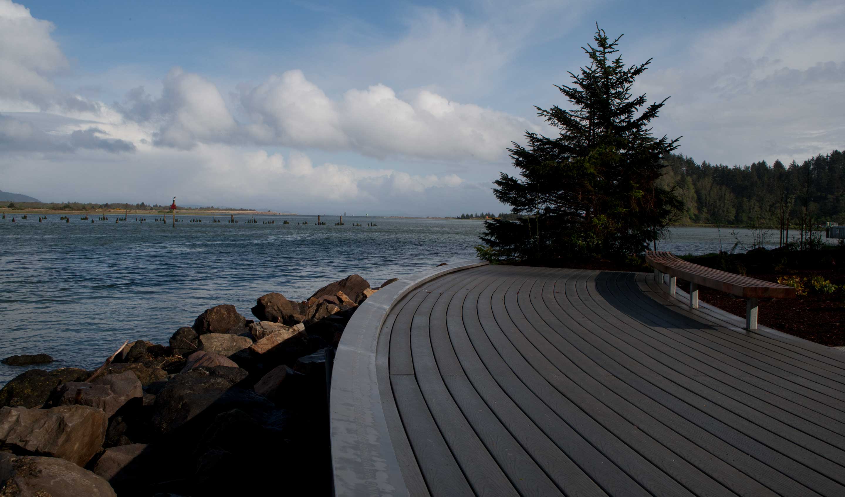
Lin envisioned a simple, curved viewing platform echoing the curve of the shoreline on the bay side of Cape Disappointment. A few lines of text on the front edge of the platform underline the historical and ecological significance of this spot. Underneath the platform, rock work was needed to support the fragile shoreline and new structure. Native plantings by the water’s edge are part of a catch basin, to contain polluted runoff. Varying high waterlines were determined to plan areas for marsh and wet meadow plantings.
An oyster-shell concrete pathway leads from the fish cleaning table, along a swale, to the edge of Baker Bay. Lin chose crushed oyster shell for aesthetic and environmental reasons, as well as a reminder that oysters had been a mainstay of the Chinook people just north at Willapa Bay. The path runs alongside restored wetlands planted with common ladyfern and Henderson’s checker mallow. Short sections of the path bridge over wet meadow plantings of tufted hairgrass and western buttercup. The cedar viewing platform and bench curves outward to invite a look across the bay. Laser-cut into the raised metal front of the platform is a Corps of Discovery journal excerpt in which Patrick Gass recorded his admiration of the bay on their arrival at this spot.
Amphitheater Trail
Lin proposed raising the level of the ground at the amphitheater to a natural slope, high enough to see the sun set into the ocean beyond the dunes. Dune restoration and plantings of dunegrass in this area were an element of her vision. Flat lawn was to be torn out, and the area regraded to create rolling forms. Facing due west, the amphitheater’s curving cedar benches and stage were plotted out to repeat the same radius curve of the estuary viewing platform.
The completed gently curving trail leads from the coastal forest, through restored dunes, behind the amphitheater, to an art installation among trees–the Cedar Circle. From above, the crushed oyster shell trail has regular nodes along it, almost resembling the nodes of a reed. While walking the path, its nodes are visible as sections of concrete with the words of a Chinook praise song. A tribal leader recited the praise song here on November 18, 2005, the 200th anniversary of the Corps of Discovery’s arrival at the site. The song’s verse and refrain form is displayed visually as each appears at intervals on the path.
Lin has said that sometimes, when she does her work well, that people may not even realize it is there. Here on the trail among dunes, there is no need to draw boundaries between landscape, environmental restoration, and art installation.
Cedar Circle
I’ve chosen to take seven driftwood trees that had washed up on the shores of Waikiki Beach and erect them there. –Maya Lin
An initial color design rendering showed sections of upright cedar driftwood logs at the back of the amphitheater. The bare logs appear pale and ghost-like in contrast to the deep green of the living trees. Lin chose logs from the beach, some fairly straight, others bulging with stubs of their former roots and branches. Considering each one further as a sculptural element followed –studying their forms, and planning their placement. The logs were analyzed to ensure they would be structurally sound when erected on a concrete platform. Project engineers custom-tailored steel supports to fit the form of each log, as unobtrusively as possible.
Where grasses give way to trees, Maya Lin installed sections of cedar driftwood in a roughly circular arrangement. At the center of the circle sits an ancient cedar tree section, predating the arrival of the Corps of Discovery. Its surface reveals the rings of its venerable age. The six driftwood logs plus the ancient center recall the directions known to Native people–north, south, east, west, up, down, and in. A bed of oyster shell lies beneath the stump and and the closest standing logs. A little further away, the other standing logs are intermingled with the living trees.
Lin’s choices to work with cedar, basalt, oyster shell and driftwood are a result of her interest in exploring the nature of the site and creating work connected to its environment at Cape Disappointment. Looking at driftwood on the beach as an array of forms also brought to mind the giant living trees the logs had been, and the timber industry that flourished nearby.
Boardwalk
It’s symbolically the last walk along the confluence journey. As you take that walk, you’re walking through a summary statement of all the places they travelled through along their journey, counting it out mile to mile. What you realize is that you are walking through all these different homelands. –Maya Lin
On the ocean side of the park, design work for a boardwalk called for putting in new native plantings on either side. Starting next to an alder grove, the boardwalk curves past dunegrass, sedge, and red fescue. It then concludes at Waikiki Beach. Lin selected text from the Lewis and Clark journals to appear along the way, and chose to have the text inscribed into stone and inlayed within the oyster shell concrete planks.
The length of the boardwalk represents the full 4133-mile journey of the Corps of Discovery, from St. Louis to this spot on the Pacific. Spacing of the text was plotted out to be in scale to the miles traveled on their journey. Tribal and place names would be placed in proportion to the distances between them.
Walking the boardwalk features views of restored dunes, then driftwood and waves on the sand of Waikiki Beach. It also features text from the Lewis and Clark journals listing all the places they traveled through, the distances between them, and Native American tribes they encountered along the way. Their journey can be experienced by reading the names while walking the relative distances between all these places. On the way to the beach, entries appear from their journey westward to the Pacific Ocean on the left side of the boardwalk. While walking back from the beach, entries from their return east to St. Louis also appear on the left side.
Dedication
We had a very big dedication, and in the middle of the blessing an eagle flew over. One of the Chinook elders cut the first fish to dedicate the table. It’s been great for the community…It’s certainly made people think about what you could do out in a landscape. When you walk around in it with the landscape scale, it changes how you think about where you are. –Kathleen Sayce, Shore Bank Pacific, Ilwaco
Maya Lin’s objectives were stewardship oriented, to restore and preserve and interpret natural processes and the cultural heritage of our state. There was a synergy between her efforts and ours. –Daniel Farber, Washington State Parks
200 years to the day after the Corps of Discovery arrived at Cape Disappointment, the Confluence Project dedicated the site. On November 18, 2006, nearly three hundred people–community leaders, Chinook tribal members, arts supporters, politicians, and folks–gathered for the occasion. Since that time, the new amphitheater has brought people together for a number of daytime concerts and events.