In the previous blog we explored total solar eclipses of the Pacific Northwest from 1503 to 1806. By the date of the next total solar eclipse in 19th century North America, scientists were prepared to study all phenomenon and data figures that their instruments and observations could perceive. After searching through every possible journal available to me with regard to the total solar eclipse of November 30, 1834, I came to the conclusion that the eclipse was likely not noticed at all in the Pacific Northwest. The day after the prophesied date (and written without a mention of the moon or sun) December 1, 1834, ornithologist John Kirk Townsend and his distinguished colleague botanist Thomas Nuttall prepared to sail for the temperate climate of the Sandwich Islands. The two pioneer scientists had only arrived at Fort Vancouver in late September 1834, having crossed nearly half the continent and 3,000 miles on foot and horseback. Dreary rain and chilly weather helped persuade the two naturalists to sail aboard the Mary Dacre to Hawaii in December 1834.
It is probably safe to assume that the 1834 solar eclipse found no light or darkness in the Pacific Northwest. In the east scientists were revved to measure the “magnetic dip” observed during the eclipse at Baltimore, West Point, Providence, Springfield and Albany.[1] The U.S. Coast Survey service appointed ships and officers to make specific observations. The Navy appointed F.R. Hassler to assist in the collection of Coast Survey data at Washington, D.C., and with assistants, help to assemble a report about the November 30, 1834 eclipse. A real kerfuffle arose when Acting Secretary of the Navy John Boyle received Mr. Hassler’s invoice for expenses of transportation for researchers and instruments. To insure their timely arrival with instruments intact, the scientists hired a coach and four horses for the journey from Washington City to New York. Apparently, the Navy had expected them to travel on a much slower naval vessel and risk missing the eclipse altogether. Four federal accounting offices examined and denied the bill for $412.25 plus a $5.64 commission (totaling roughly $11,300 today!) Eventually, in 1835 the government paid it in full.
July 18, 1860
The recorders of the 1860 solar eclipse were not as fortunate as Mr. Hassler when it came to an expense account. “There seemed too little probability of favorable results from an expedition to observe the total eclipse from the west side of the American continent,“ wrote Lieutenant J. M. Gilliss, USN, “to justify the dispatch either of many assistants or of an elaborate equipment of instruments. Experienced gentlemen, or those who were supposed to be so, and were consulted, pronounced that portion of Washington Territory which the total shadow-path would traverse rugged, crossed by dangerous torrents, caused by the snows melting at that season, and covered by dense forests, which would be likely to obstruct vision in almost every direction. They thought that a suitable site would be attainable only after cutting a path through immense forest trees to some mountain top of the Cascade range.” [2]
The budget for the U.S. Coast Survey was extremely limited.[3] Gilliss also remarked that the government was skeptical about the weather in Washington Territory at five in the morning, suggesting that heavy fogs and mists might prevail in the mountains around Puget Sound or at Cape Disappointment.
In addition to the “natural hindrances” expected, securing transportation for the astronomers and their equipment loomed as a major threat. General Thomas S. Jesup, U.S. Army Quartermaster General, stepped forward and instructed the quartermaster at Fort Vancouver, on the Columbia River, to supply as many pack mules as might be required for the service. At last, the project was a “go.” [4] Once on the scene, the surveyors discovered much misinformation and “guess work” had been provided by their Eastern colleagues and found more trustworthy information among those who lived in Washington Territory. Gilliss wrote, “… reliable information was gained from an officer of the Hudson’s Bay Company, who had made many journeys through the Yakima country between Vancouver, on the Columbia river, and Nisqually, on Puget’s sound. “[5]
The HBC man directed them away from the mountaintops and to the close-by prairies where the sunrise was detected as early as it would be in the mountains. Gilliss noted, “Topographical. —The spot selected for camp is a knoll of slight eminence on Muck prairie, west of the road, and one mile north of where a stream of the same name crosses it. The surface of the ground is rolling and the prairie about a mile wide between the nearest eastern and western belts of pine and hemlock trees. Two hundred yards north of the camp ground there is a clump of trees extending three-fourths of a mile from the road in a southeasterly direction, the eastern boundary of this clump being a nearly north and south line. Between the southeast corner of the clump and the eastern belt bounding Muck prairie there is an open space of half a mile which permits a view in the direction of sunrise, (at that time of the year.) Above the pine and fir-belt seen in this last direction, and some five miles distant, a very slight eminence of the Cascade mountains is visible, its elevation above the ground line being 32′ 20″. Assuming the (magnetic) variation to be 22° easterly, the bearing of the centre of the eminence is N. 64° E. ; and that of Mt. Rainier, a lofty snow-clad summit of the same range, S. 33° E.”[6]
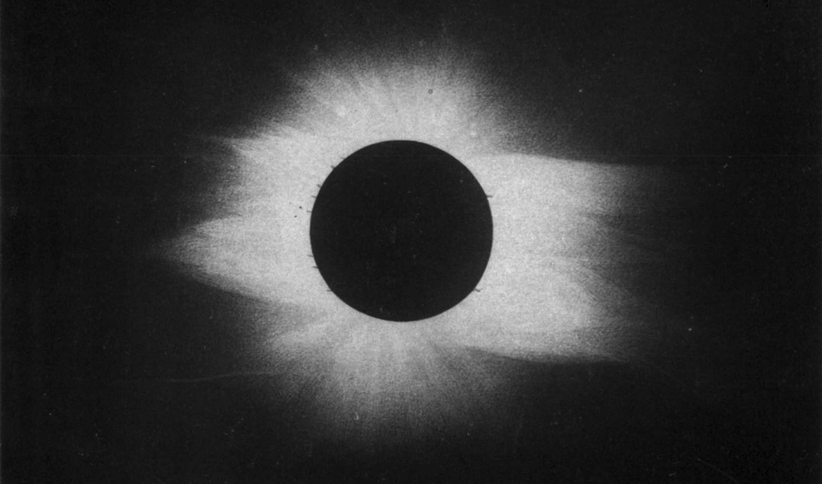
This eclipse originated off of Cape Disappointment and traversed across the globe to the Sudan. It was described by the New York Times, July 18, 1860. Its effect upon the northwest was immediate:
“By the time this journal reaches this morning’s breakfast-table — at 7 h. 10 m. 21.3 sec., A.M., from the longitude of the TIMES Office, (to be astronomically precise) –the great solar eclipse long foretold in the prophecy of mathematics, will have begun for us. We do not, in these latitudes’ indeed, come under the line of total obscuration — the great cone of shadow which the moon projects behind her on the whirling earth, sweeps across our upper latitudes, from the mouth of the Columbia River, in Washington Territory, to Cape Chidley, in Labrador, in a black belt seventy miles wide, traveling at the speed of 1,850 miles an hour, or four times the velocity of a cannon-ball! New-York falls under the line of “six digits eclipsed,” and under this line, precisely the northern half of the sun will be obscured.”[7]
The Times story continued to laud the eclipse origins in the Northwest:
“The umbra, or total dark shadow of the moon, first comes in contact with the earth in the Pacific Ocean, one hundred miles west of Oregon, directly west of Oregon City, and a little to the southwest of the mouth of the Columbia River: it then passes in a northeasterly direction over British America to Hudson’s Bay, near Fort York, at the mouth of Nelson’s River, crossing Hudson’s Bay and Labrador to Cape Chidley …. It then enters the Atlantic Ocean, passing due east until nearly south of Cape Farewell, the southern cape of Greenland, where the sun will be totally eclipsed at noon of that place. Thence it takes a curved line towards the southeast, passing over the north of Spain, the Mediterranean Sea, Algiers, Tripoli, Fezzan, the southwestern corner of Egypt into Nubia, where it will leave the earth near the Red Sea, a little before the setting of the sun at that place.”[8]
This was likely the broadest mention of Pacific Northwest places in a decade for The Times. The total duration of the eclipse was estimated from start to finish at 3 minutes: “The eclipse is total soon after sunrise in several villages in Oregon and Washington Territory, but not elsewhere in the United States. At Olympia, the capital of Washington Territory, in lat. 47 deg. m., long. 122 deg. 55 m., the duration of totality is 1 m. 52.6 s., or about one-half its duration when the eclipse is central in the North of Spain.”[9]
The editor of the Indiana Medical Journal, Alembert W. Brayton, well remembered the 1860 solar eclipse and its affects in the Pacific Northwest. He was present July 18, 1860, in Washington Territory and wrote, “The moon’s shadow advanced with terrifying swiftness—two or three thousand miles an hour—from the distant western horizon, enveloping the observer; the air seemed to quiver, and on every white surface alternate light and dark bands or fringes appeared parallel to the edges of the shadow— an irregular light refraction from the narrow sun’s edge as it was on the point of disappearing.” [10]
On the eve of the American Civil War, the sciences and technologies were advancing at a rapid rate and the eclipse of July 18, 1860, helped focus these efforts. The Photographic News of 1888, recalled for its readers, “Probably the most important services which have been rendered by photography to science are in the domains of astronomy. … For some time, photographs have been regularly taken of the sun’s surface; indeed, of recent years, a photograph of the sun for every day of the year has been obtained from some part or other of the earth. The exposure for them is made by a very narrow slit, passing rapidly across the field of view. The value of photography in the short period of time available for observation during solar eclipses is well known since the eclipse of July 18, 1860.”[11]
Within that decade, yet another solar eclipse drew attention to the Northwest and the newly acquired territory of Alaska. At the end of the Civil War, Secretary of State William Seward pushed hard for the purchase of resource rich Alaska from the Russian czar. Appointed by President Lincoln in 1861, Seward was badly wounded in the assassination plot against President Lincoln and his cabinet. President Johnson continued Seward’s position through his term and presidential impeachment until 1869 when U.S. Grant took the oath of office. “Seward’s Folly” was the nickname for the treaty signed by Seward March 30, 1867 with the Russian government securing the purchase of the Alaskan territory for $7.2 million dollars or roughly two cents per acre. Russia was eager to sell to prevent the United Kingdom seizing the vast territory if Russia went to war against the British. The Hudson’s Bay Company had established several posts in British Columbia and near the Alaskan borders and they had sold produce and meat to the Russian forts for over forty years from Fort Vancouver on the Columbia and from Fort Nisqually near Puget Sound. The Senate ratified the treaty in less than two weeks.[12]
The Civil War distracted public attention from Westward development for most Americans in the 1860’s, but after the war and throughout Reconstruction, many people looked for new horizons for settlement and riches. The Transcontinental Railroad was completed between 1863 and 1869, and people and business flowed west, then east again. Alaska seemed even more remote than the Pacific Northwest, reaching it by sail or steamship from ports on the West Coast. In 1867, the United States Coast Survey was assigned the duty of escorting a scientific team to make a geographical reconnaissance of the coast wherever practical; reporting the physical features and resources of the country as far as a short season in the north would permit.[13]
The Coast Survey crew was very popular when they returned to Washington, D.C. in 1867-68, due to the keen interest of citizens and the media with regard to Alaska. In 1869, they were ordered again to Alaska to observe and record the total solar eclipse on August 7, 1869. They set out from Sitka, where General Jefferson C. Davis[14] had built an army post as the first Commander of the Department of Alaska. Several Russian families were turned out of their homes to make room for more Americans. With Davis’s military support, the Coast Survey crew set out with a boat load of instruments and a war canoe powered by a Sitka Chief and five armed Sitka paddlers. The war canoe was packed with provisions and camping gear. In the eleven day passage to Klu-kwan’ on the Chilkat River, they were fired upon several times. [15]
In February 1868, Davidson wrote to Governor James Douglas of the Hudson’s Bay Company on Vancouver Island hoping to glean information about the indigenous peoples of the Chilkat River region. In May 1868, the Governor kindly replied with apologies that HBC people knew little of travel or character of the rivers in that part of the country.[16] Douglas recommended as a guide a retired HBC chief trader – George Blenkensop – a “gentleman of great intelligence and large experience”[17] who had built and managed the HBC post at Stikine. No word if Davidson followed up with this recommendation. Douglas also commented that the natives of the Chilkat and Tacow Rivers constituted a very powerful tribe and “used to be excessively saucy and turbulent, though not dishonest, nor destitute of a rough, generous hospitality.” Douglas further wrote, “They have probably improved in their manners, since the time I refer to, nearly 20 years ago, as they now keep up a constant intercourse with the white settlements both Russian and British.”[18]
The recently retired Secretary of State William Seward made his first and only journey to Alaska to view the solar eclipse. Davidson wrote, “[Seward] arrived at the mouth of the Chilkaht two days before the eclipse, and we sent a swift canoe down to bring him up. He was received with great gravity and ceremony by Koh-klux and his chiefs, and about four hundred men and women.”[19] The Coast Survey officers accompanied Seward aboard the steamer Active for the next 12 days as they skimmed through the channels of Archipelago, through the interior straits and channels to Victoria, B.C., and then on to Portland and San Francisco.
From all recorded accounts, documentation of the total solar eclipse on the Chilkat River in Alaska met with great success.
Next time we will look at the next two fascinating eclipses of the nineteenth century. In 1878, the sun was eclipsed during the Bannock War and in 1889, one of the greatest scientific efforts to record and compare a total solar eclipse was launched.
End Notes
End Notes:
[1] Bache, A.D. and Edward H. Courtenay. “Observations to Determine the Magnetic Dip at Baltimore, Philadelphia, New York, West Point, Providence, Springfield and Albany.” Transactions of the American Philosophical Society 5 (1837). 209-215. http://www.jstor.org/stable/pdf/1004945.pdf?refreqid=excelsior%3Af20de82fcf949e222a7cb24459b6299c[2] Gilliss, Lt. James Melville. “An Account of the Total Eclipse of the Sun, July 18, 1860 at Steilacoom, Wash. Terr. in U.S. Coast Survey.” Washington: Washington City, 1860.
[3] Under “Public Resolutions” of Congress and the US Government for 1860 is Article No. 20: A Resolution providing for the Observation of the Eclipse of the Sun which will occur on the eighteenth day of July next. The Superintendent of the Coast Survey is the eighteenth day of July next. The Superintendent of the Coast Survey is directed to procure and equip a suitable vessel to carry not over five astronomers and their assistants, to the most suitable point on the eastern coast of this continent, for observing the eclipse; the United States to be at no other expense, and to furnish their observations fur the use of the Coast Survey, without charge to the Government June 15, 1860. at London. July 18. —The eclipse of the sun is observed, among others, by the British Expedition in Spain and the American Expedition in Labrador July 20-21.
[4] Ibid.
[5] Gilliss. “An Account of the Total Eclipse of the Sun, July 18, 1860 at Steilacoom, Wash. Terr. in U.S. Coast Survey.”
[6] Ibid.
[7] “The Total Solar Eclipse.; Time of its Occurence Track of the Moon’s Shadow Points of Observation Work of the Astronomers Method of Calculation.” The New York Times, July 18, 1860. http://www.nytimes.com/1860/07/18/news/total-solar-eclipse-time-its-occurrence-track-moon-s-shadow-points-observation.html?pagewanted=all
[8] Ibid.
[9] Ibid.
[10] The editor states that he was present for the total solar eclipse in Washington Territory on July 17, 1860. Brayton, Alembert W. The Indiana Medical Journal, 24 no. 1. Indiana: 1905. https://goo.gl/xJXk67
[11] The Photographic News, 32 no. 1. London: Cassell, Petter, and Galpin, 1888.
[12] Virtual Programs and Services. “Treaty with Russia for the Purchase of Alaska: Primary Documents of American History.” Library of Congress. https://www.loc.gov/rr/program/bib/ourdocs/Alaska.html
[13] Davidson, George. The Alaska Boundary. Alaska: Alaska Packers Association, 1903. 13.
[14] General Jefferson Columbus Davis (March 2, 1828 – November 30, 1879) was a regular officer in the United States Army during the American Civil War, known for the similarity of his name to Confederate President Jefferson Davis and for his killing of a superior officer in 1862. Davis was the first commander of the Department of Alaska, and he assumed field command during the Modoc War of 1872-73 in the Department of the Columbia.
[15] Davidson. The Alaska Boundary. 13.
[16] Ibid. 233.
[17] Ibid. 235.
[18] Ibid. 234.
[19] Ibid. p. 14